
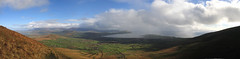
OK so I’ve discovered geotagging for flickr images, which allows you to pinpoint where on the planet your photo was taken. This may not be particularly useful for abstract images, but is very useful if you have a particular interest in a place. I’ve also started to use stitching software to join up multiple images into one seamless panorama, so it seems that geotagging, stitching and flying to these locations (using RobRoys excellent flickrfly coding) withGoogle Earth could be fun, and almost in the spirit of Web 2.0 whatever that may me. So here, for the moment is a panorama taken from Mount Eagle, the most westerly place in Europe. I took the sequence of shots in October ’04, but it has taken till now to offer this up. Enjoy flying there in Google Earth, however the satellite imagery isn’t great (yet) for that part of the world.
Don’t be put off by the small image size above, if you click the image, you’ll be taken to flickr where you can see it in all its glory.